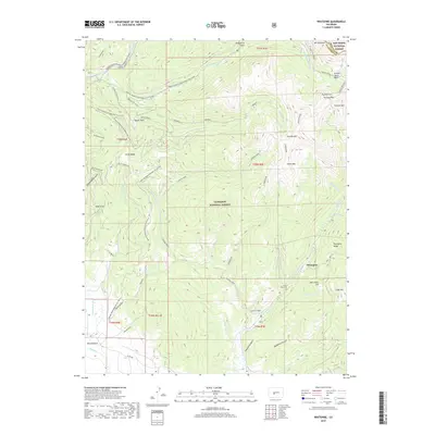
2019 Map of Whitepine
USGS Topo · Published 2019About this map
Whitepine sits at the high elevations of the Continental Divide, surrounded by the high peaks and glacial basins of the Gunnison National Forest. This modern survey records the high-altitude landscape where the headwaters of Tomichi Cr and Canyon Creek emerge from the steep slopes of Stella Mtn and Granite Mtn. The map documents a geography defined by its mining and recreational history, from the White Pine Cem to the modern winter corridors of the Cumberland Pass Snowmobile/Ski (Snow) route. The rugged character of the Sawatch Range is evident in the naming of features like Brittle Silver Basin and Tomichi Pass, reflecting the area's prospecting legacy. In the southern portion of the quadrangle, the terrain levels slightly into the valley near Waunita Park, where Hot Springs Cr flows through the mountain meadows.
Find a feature on this map
56 named features on this map. Tap any name to fly to it.
Don’t see what you’re looking for? This feature index may not catch every label — zoom into the map to look around manually.
Map Details
Editions of this 2019 Whitepine Map
This is the sole edition of this map. No revisions or reprints were ever made.
Other maps of this area

1940 · Garfield
USGS Topo · 1:62,500

1941 · Pitkin
USGS Topo · 1:62,500

1945 · Pitkin
USGS Topo · 1:62,500

1945 · Garfield
USGS Topo · 1:62,500

1956 · Montrose
USGS Topo · 1:250,000

1959 · Montrose
USGS Topo · 1:250,000

1960 · Montrose
USGS Topo · 1:250,000

1962 · Doyleville
USGS Topo · 1:24,000
1964 · Pitkin
USGS Topo · 1:24,000

1964 · Sargents
USGS Topo · 1:24,000