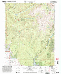
2001 Map of Whitepine
USGS Topo · Published 2004About this map
Whitepine and the surrounding high-country mining districts of the Gunnison National Forest define this 2001 revision of a 1982 survey. The topography is dominated by the steep drainages of North Quartz Creek, Middle Quartz Creek, and South Quartz Creek, which converge as they flow toward the Continental Divide. Evidence of the region's industrial past is visible in the concentrations of mineral extractions, including the North Star Mine and Akron Mine, located near the mountain pass. Cultural sites such as a Cem near the creek and the residential pockets at Eldorado and Waunita Park show the scattered settlement patterns of the Gunnison and Chaffee county line. High peaks like Stella Mountain and Granite Mountain overlook a complex network of gulches and canyons, including Snowblind Gulch and Triano Creek.
Find a feature on this map
44 named features on this map. Tap any name to fly to it.
Don’t see what you’re looking for? This feature index may not catch every label — zoom into the map to look around manually.
Map Details
Editions of this 2001 Whitepine Map
This is the sole edition of this map. No revisions or reprints were ever made.
Other maps of this area

1940 · Garfield
USGS Topo · 1:62,500

1941 · Pitkin
USGS Topo · 1:62,500

1945 · Pitkin
USGS Topo · 1:62,500

1945 · Garfield
USGS Topo · 1:62,500

1956 · Montrose
USGS Topo · 1:250,000

1959 · Montrose
USGS Topo · 1:250,000

1960 · Montrose
USGS Topo · 1:250,000

1962 · Doyleville
USGS Topo · 1:24,000
1964 · Pitkin
USGS Topo · 1:24,000

1964 · Sargents
USGS Topo · 1:24,000