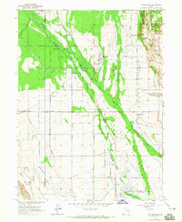
1964 Map of Whiterocks
USGS Topo · Published 1965About this map
Uintah and Ouray Indian Reservation land dominates this 1960s survey, illustrating a landscape where complex water management and indigenous heritage intersect. The Uintah River and Whiterocks River feed an extensive network of irrigation infrastructure, including the Whiterocks Canal, Larsen Ditch, and Independent Ditch. These systems support the settlements of Whiterocks and Hayden, while significant cultural sites such as the Indian Sun Dance Grounds and the Fort Robidoux Historical Monument indicate the long-standing human presence in the Uinta Basin.
Find a feature on this map
53 named features on this map. Tap any name to fly to it.
Don’t see what you’re looking for? This feature index may not catch every label — zoom into the map to look around manually.
Map Details
Editions of this 1964 Whiterocks Map
This is the sole edition of this map. No revisions or reprints were ever made.
Other maps of this area

1885 · Ashley
USGS Topo · 1:250,000

1885 · Uinta
USGS Topo · 1:250,000

1905 · Gilbert Peak
USGS Topo · 1:125,000

1906 · Gilbert Peak
USGS Topo · 1:125,000

1906 · Marsh Peak
USGS Topo · 1:125,000

1908 · Marsh Peak
USGS Topo · 1:125,000

1917 · Vernal
USGS Topo · 1:125,000

1939 · Duchesne
USGS Topo · 1:125,000

1954 · Salt Lake City
USGS Topo · 1:250,000

1954 · Vernal
USGS Topo · 1:250,000