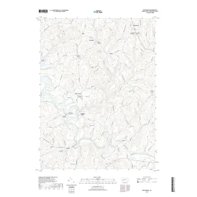
2019 Map of Whitesburg
USGS Topo · Published 2019About this map
Crooked Creek snakes through the southern reaches of this Armstrong County landscape, defining the topography of an area steeped in local religious and genealogical history. The settlement pattern is characterized by small, dispersed communities such as Cochrans Mills, Brick Church, and Whitesburg, each centered around historic congregations and their associated burial grounds. For researchers, the density of named cemeteries is significant, ranging from the Whitesburg Presbyterian Church Cem in the northeast to the Shellhammer Cem near Mateer in the southwest. The intricate network of township roads and runs, including Cherry Run and Pine Run, connects these long-standing rural outposts. The map reveals the deep-seated heritage of the region's Lutheran and Brethren communities, preserved through sites like the Dunkard Baptist Christian Bretheren Cem and the Saint Michaels Lutheran Church Cem.
Find a feature on this map
146 named features on this map. Tap any name to fly to it.
Don’t see what you’re looking for? This feature index may not catch every label — zoom into the map to look around manually.
Map Details
Editions of this 2019 Whitesburg Map
This is the sole edition of this map. No revisions or reprints were ever made.
Other maps of this area

1900 · Kittanning
USGS Topo · 1:62,500

1901 · Rural Valley
USGS Topo · 1:62,500

1902 · Kittanning
USGS Topo · 1:62,500

1902 · Elders Ridge
USGS Topo · 1:62,500

1903 · Rural Valley
USGS Topo · 1:62,500

1904 · Elders Ridge
USGS Topo · 1:62,500

1907 · Freeport
USGS Topo · 1:62,500

1909 · Freeport
USGS Topo · 1:62,500

1953 · Pittsburgh
USGS Topo · 1:250,000
1953 · Vandergrift
USGS Topo · 1:24,000