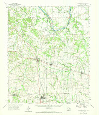
1958 Map of Whitesright
USGS Topo · Published 1973About this map
The Red River defines the northern border of this North Texas landscape, where the agricultural plains of Grayson and Fannin Counties meet the Oklahoma state line. The region is defined by a dense network of early crossroads and rail-oriented settlements, including the prominent junction at Whitewright and the nearby historic community of Kentucky Town. The mapping reflects a landscape of small family farms and rural institutions, evidenced by the high concentration of named burial grounds such as Montgomery Cem, Little Jordan Cem, and Porter Cem. Transportation is dominated by the Missouri Kansas Texas RR and the Texas and Pacific RR, which connect towns like Savoy, Bells, and Tom Bean. Along the river bottomlands, the terrain shifts into a complex of sloughs and sand deposits, notably Choctaw Slough and Gandy Slough.
Find a feature on this map
102 named features on this map. Tap any name to fly to it.
Don’t see what you’re looking for? This feature index may not catch every label — zoom into the map to look around manually.
Map Details
Editions of this 1958 Whitesright Map
2 editions found
Other maps of this area

1901 · Denison
USGS Topo · 1:125,000

1954 · Sherman
USGS Topo · 1:250,000

1957 · Wade
USGS Topo · 1:62,500

1957 · Denison Dam
USGS Topo · 1:24,000

1958 · Durant
USGS Topo · 1:62,500

1958 · Bonham
USGS Topo · 1:62,500

1958 · Whitesright
USGS Topo · 1:62,500

1958 · Denison Dam
USGS Topo · 1:62,500

1958 · Sherman
USGS Topo · 1:250,000

1958 · Sherman
USGS Topo · 1:62,500