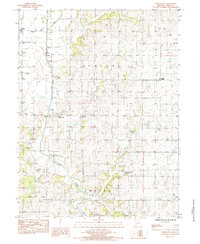
1984 Map of Whitesville
USGS Topo · Published 1985About this map
The Platte River meanders through this portion of Andrew County, its course defined by numerous Sand Areas and the confluence of several local waterways. Small agricultural hubs like Whitesville and Empire Prairie anchor the rural landscape, connected by a network of country roads that follow the section lines of the survey grid. Near the river's bend, Elrod Mill State Access Area provides a point of entry to the water, while the presence of scattered Cem markers and rural settlements like Flag Springs and Cawood offer a look into the local genealogy and township development of the mid-1980s. The terrain is deeply dissected by a drainage network including Hickory Creek, Clear Creek, and Agee Creek, which have carved the surrounding Empire and Platte uplands over time.
Find a feature on this map
19 named features on this map. Tap any name to fly to it.
Don’t see what you’re looking for? This feature index may not catch every label — zoom into the map to look around manually.
Map Details
Editions of this 1984 Whitesville Map
This is the sole edition of this map. No revisions or reprints were ever made.
Other maps of this area

1923 · Clarksdale
USGS Topo · 1:62,500

1924 · St. Joseph
USGS Topo · 1:62,500

1925 · Clarksdale
USGS Topo · 1:62,500

1925 · Stanberry
USGS Topo · 1:62,500

1926 · Saint Joseph
USGS Topo · 1:62,500

1927 · Bolckow
USGS Topo · 1:62,500

1939 · Stanberry
USGS Topo · 1:62,500

1943 · Stanberry
USGS Topo · 1:62,500

1945 · Bolckow
USGS Topo · 1:62,500

1950 · Kansas City
USGS Topo · 1:250,000