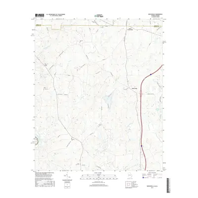
2017 Map of Whitesville
USGS Topo · Published 2017About this map
Whitesville serves as the central hub of this West Georgia landscape, situated in Harris County near the Troup County line. The area is defined by a dense network of tributaries flowing toward the western boundary, including Flat Shoal Creek, Mountain Oak Cr, and Sand Cr. These waterways carve through a terrain dotted with small family and community burial grounds, such as Billingslea Cem, Hutchinson Cem, and Shady Grove Cem, which provide significant points of interest for genealogists and local historians. North of town, Jones Crossroads marks a traditional junction of rural routes. The map detail reflects a modern rural environment where historic land divisions meet newer developments like Callaway Enterprises Lake and the recreational waters of Pine Lake. Transport and access are dictated by a mix of established roads like Marshall Williams Rd and New Hope Cemetery Rd, alongside the prominent crossing at Flat Shoals Bridge.
Find a feature on this map
53 named features on this map. Tap any name to fly to it.
Don’t see what you’re looking for? This feature index may not catch every label — zoom into the map to look around manually.
Map Details
Editions of this 2017 Whitesville Map
This is the sole edition of this map. No revisions or reprints were ever made.
Other maps of this area

1907 · Talbotton
USGS Topo · 1:125,000

1907 · Opelika
USGS Topo · 1:125,000

1909 · Opelika
USGS Topo · 1:125,000

1950 · Mulberry Grove
USGS Topo · 1:24,000

1950 · Ellerslie
USGS Topo · 1:62,500
1955 · Mulberry Grove
USGS Topo · 1:24,000
1955 · Ellerslie
USGS Topo · 1:62,500

1955 · Phenix City
USGS Topo · 1:250,000

1957 · Phenix City
USGS Topo · 1:250,000

1958 · Phenix City
USGS Topo · 1:250,000