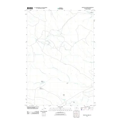
2011 Map of Whitetail Creek
USGS Topo · Published 2011About this map
Whitetail Creek and its numerous tributaries dominate this Carter County landscape, revealing a high-plains environment meticulously managed for water storage. The drainage network is dense, featuring the North Fork Whitetail Creek, Middle Fork Whitetail Creek, and South Fork Whitetail Creek, which all converge as they flow eastward. This hydrological pattern is punctuated by several man-made structures essential for ranching and conservation, such as the Whitetail Detention Dam and the Lostcalf Dam. These features, along with named landmarks like the Two D-4 Ranch Dam, suggest a long-standing reliance on small-scale reservoirs to support life in this corner of Montana. Transportation in the area is limited to rural routes like Hopkin's Rd and Cottonwood Rd, which navigate the terrain around Muskrat Creek and the southern Aldrich Draw.
Find a feature on this map
16 named features on this map. Tap any name to fly to it.
Don’t see what you’re looking for? This feature index may not catch every label — zoom into the map to look around manually.
Map Details
Editions of this 2011 Whitetail Creek Map
This is the sole edition of this map. No revisions or reprints were ever made.
Other maps of this area

1954 · Ekalaka
USGS Topo · 1:250,000

1956 · Ekalaka
USGS Topo · 1:250,000

1958 · Ekalaka
USGS Topo · 1:250,000

1965 · Ekalaka
USGS Topo · 1:250,000

1979 · W L Butte
USGS Topo · 1:24,000

1979 · Dutchman Creek
USGS Topo · 1:24,000

1979 · Ikey Creek
USGS Topo · 1:24,000

1981 · Alzada
USGS Topo · 1:100,000
1982 · Whitetail Creek
USGS Topo · 1:24,000

1982 · Phillippi Reservoir
USGS Topo · 1:24,000