
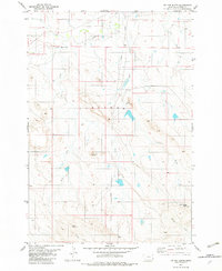
1982 Map of Phillippi Reservoir
USGS Topo · Published 1982About this map
Phillippi Reservoir lies at the heart of this rangeland in Carter County, where a network of seasonal drainages shapes the landscape. The Boxelder Sch stands as a focal point for the surrounding rural community, situated near the winding course of Boxelder Creek. The terrain is defined by distinct topographical markers like the Flattops and the confluence of Big Groat Creek and Little Groat Creek. Economic activity is evidenced by scattered infrastructure, including several Drill Holes and Landing Strips, reflecting the region's reliance on aviation and resource exploration. Traces of early water management are visible along North Soda Creek and Soda Creek, which feed into the central reservoir system. The map also documents named water features such as Hay Creek and Spring Creek, providing a detailed look at the drainage patterns of this Montana prairie.
Find a feature on this map
22 named features on this map. Tap any name to fly to it.
Don’t see what you’re looking for? This feature index may not catch every label — zoom into the map to look around manually.
Map Details
Editions of this 1982 Phillippi Reservoir Map
This is the sole edition of this map. No revisions or reprints were ever made.
Other maps of this area

1954 · Ekalaka
USGS Topo · 1:250,000

1956 · Ekalaka
USGS Topo · 1:250,000

1958 · Ekalaka
USGS Topo · 1:250,000

1965 · Ekalaka
USGS Topo · 1:250,000
1970 · Hammond
USGS Topo · 1:24,000
1970 · Greasy Hill
USGS Topo · 1:24,000

1981 · Alzada
USGS Topo · 1:100,000
1982 · Whitetail Creek
USGS Topo · 1:24,000
1982 · Knudson Draw
USGS Topo · 1:24,000
1982 · Tip Top Butte
USGS Topo · 1:24,000