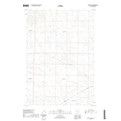
2020 Map of Whitetail Creek
USGS Topo · Published 2020About this map
The hydrological network of Carter County dominates this high-plains landscape, where the confluence of several seasonal watercourses defines the local drainage. Primary among these are the northern, middle, and southern branches of the namesake creek, including N Fork Whitetail Cr, Middle Fork Whitetail Cr, and S Fork Whitetail Cr. These tributaries converge into the main channel of Whitetail Cr as it flows toward the southeast. The terrain is characterized by dissected draws and ridges, exemplified by Aldrich Draw and the path carved by Boxelder Cr. Civil infrastructure is sparse, limited to a few arterial routes like Hopkin's Rd and Hammond Rd, which navigate the various forks and draws. This 2020 survey illustrates a region where land use is dictated by the natural relief and the intermittent flow of creeks like Muskrat Cr and Timber Cr.
Find a feature on this map
15 named features on this map. Tap any name to fly to it.
Don’t see what you’re looking for? This feature index may not catch every label — zoom into the map to look around manually.
Map Details
Editions of this 2020 Whitetail Creek Map
This is the sole edition of this map. No revisions or reprints were ever made.
Other maps of this area

1954 · Ekalaka
USGS Topo · 1:250,000

1956 · Ekalaka
USGS Topo · 1:250,000

1958 · Ekalaka
USGS Topo · 1:250,000

1965 · Ekalaka
USGS Topo · 1:250,000

1979 · W L Butte
USGS Topo · 1:24,000

1979 · Dutchman Creek
USGS Topo · 1:24,000

1979 · Ikey Creek
USGS Topo · 1:24,000

1981 · Alzada
USGS Topo · 1:100,000
1982 · Whitetail Creek
USGS Topo · 1:24,000

1982 · Phillippi Reservoir
USGS Topo · 1:24,000