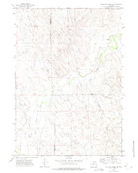
1971 Map of Whitetail Creek NE
USGS Topo · Published 1975About this map
Oil and gas infrastructure defines this corner of northeastern Wyoming during the early 1970s, where the high plains are segmented by numerous production zones. The Duvall Ranch Oil Field and Donkey Creek Oil Field dominate the northern landscape, supported by a network of buried pipelines and a centrally located Gas Plant. This area is a tri-county junction, showing the intersection of Campbell, Crook, and Weston counties. The Belle Fourche River meanders through the eastern section, providing a sharp contrast to the arid drainage patterns of Antelope Draw and Timber Creek. Industrial development is evident in the scattered Drill Hole locations and the presence of a Landing Strip in the southern reaches near the Raven Creek Oil Field. The map records an era of intensive resource extraction before the modern expansion of nearby Interstate 90 infrastructure.
Find a feature on this map
21 named features on this map. Tap any name to fly to it.
Don’t see what you’re looking for? This feature index may not catch every label — zoom into the map to look around manually.
Map Details
Editions of this 1971 Whitetail Creek NE Map
This is the sole edition of this map. No revisions or reprints were ever made.
Other maps of this area

1918 · Moorcroft
USGS Topo · 1:125,000

1918 · Moorcroft
USGS Topo · 1:62,500

1954 · Gillette
USGS Topo · 1:250,000

1955 · Gillette
USGS Topo · 1:250,000

1957 · Moorcroft
USGS Topo · 1:62,500

1958 · Gillette
USGS Topo · 1:250,000

1962 · Gillette
USGS Topo · 1:250,000

1971 · Coon Track Creek
USGS Topo · 1:24,000

1971 · Whitetail Creek
USGS Topo · 1:24,000
1971 · Whitetail Creek SE
USGS Topo · 1:24,000