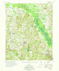
1971 Map of Whiteville
USGS Topo · Published 1971About this map
The Hatchie River dominates this West Tennessee landscape as it winds through a dense network of oxbows and wetlands, including Hatchie National Wildlife Refuge and Mulherin Bend. The river's influence is clear in the numerous small water bodies like Horseshoe Lake and Silver Moon Lake that dot the bottomlands. Settlement is concentrated along the Louisville and Nashville railroad corridor, with Whiteville serving as a primary hub. To the southeast, the expansive grounds of the Western State Hospital sit just outside Bolivar. The map reveals a deeply established rural social fabric, documented through an exceptionally high density of local institutions such as Cloverport Chapel Sch, Bartlett Chapel, and Pilgrims Rest Cem, which served the outlying communities of Mercer, Vildo, and Laconia.
Find a feature on this map
96 named features on this map. Tap any name to fly to it.
Don’t see what you’re looking for? This feature index may not catch every label — zoom into the map to look around manually.
Map Details
Editions of this 1971 Whiteville Map
This is the sole edition of this map. No revisions or reprints were ever made.
Other maps of this area

1949 · Moscow
USGS Topo · 1:62,500

1950 · Hebron
USGS Topo · 1:24,000

1950 · Middleburg
USGS Topo · 1:24,000

1950 · Sunnyhill
USGS Topo · 1:24,000

1950 · Brownsville
USGS Topo · 1:24,000

1951 · Brownsville
USGS Topo · 1:24,000

1951 · Sunnyhill
USGS Topo · 1:24,000

1951 · Middleburg
USGS Topo · 1:24,000

1951 · Hebron
USGS Topo · 1:24,000

1951 · Hickory Valley
USGS Topo · 1:24,000