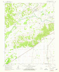
1963 Map of Whitewater
USGS Topo · Published 1979About this map
The Whitewater River and its intricate drainage network define this 1963 landscape, where the Headwater Diversion Channel redirects flow through a series of levees and gaging stations. Along the rail lines of the Missouri Pacific and St Louis Southwestern, small rail towns like Whitewater, Allenville, and Randles served as local hubs. The terrain is marked by distinctive features such as Hickory Ridge and Baker Hill, with family-named burial grounds like Proffer Cem, Passover Cem, and Hitt Cem scattered across the rural township divisions of Liberty and Welch. The mapping of the Castor River Levee and various bayous illustrates the long-standing efforts to manage the water levels in this corner of Cape Girardeau and Stoddard counties.
Find a feature on this map
47 named features on this map. Tap any name to fly to it.
Don’t see what you’re looking for? This feature index may not catch every label — zoom into the map to look around manually.
Map Details
Editions of this 1963 Whitewater Map
2 editions found
Other maps of this area

1922 · Cape Girardeau
USGS Topo · 1:62,500

1924 · Cape Girardeau
USGS Topo · 1:62,500

1933 · Marble Hill
USGS Topo · 1:62,500

1934 · Morley
USGS Topo · 1:62,500

1934 · Advance
USGS Topo · 1:62,500

1937 · Marble Hill
USGS Topo · 1:62,500

1939 · Morley
USGS Topo · 1:62,500

1939 · Advance
USGS Topo · 1:62,500

1949 · Paducah
USGS Topo · 1:250,000

1950 · Paducah
USGS Topo · 1:250,000