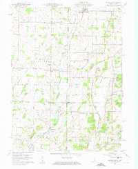
1960 Map of Whitewater
USGS Topo · Published 1961About this map
The East Fork Whitewater River and its numerous tributaries, including Gray Brook and Mud Creek, define the landscape along the Indiana and Ohio border in 1960. Small farming communities and rural intersections such as Middleboro, Braffetsville, and Whitewater are connected by a network of named roads like Overman Rd and Marine Road. The presence of several country churches and burial grounds, including Bethel Ch and Pleasant Hill Cem, indicates a deeply rooted agricultural society. To the east, the Pennsylvania railroad line cuts through the terrain near Hollansburg, while landmarks like the Pumping Sta and various Gravel Pits suggest the area's utility and industry during this era. The map also captures the local school infrastructure with the Westmont High Sch and Township Sch serving the surrounding Prairie and river valleys.
Find a feature on this map
62 named features on this map. Tap any name to fly to it.
Don’t see what you’re looking for? This feature index may not catch every label — zoom into the map to look around manually.
Map Details
Editions of this 1960 Whitewater Map

Other maps of this area

1915 · New Paris
USGS Topo · 1:48,000

1916 · Winchester
USGS Topo · 1:48,000

1918 · Winchester
USGS Topo · 1:62,500

1918 · New Paris
USGS Topo · 1:62,500

1943 · Winchester
USGS Topo · 1:62,500

1953 · Cincinnati
USGS Topo · 1:250,000

1953 · Muncie
USGS Topo · 1:250,000

1956 · Muncie
USGS Topo · 1:250,000

1957 · Cincinnati
USGS Topo · 1:250,000

1960 · New Madison
USGS Topo · 1:24,000