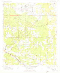
1971 Map of Whitfield
USGS Topo · Published 1973About this map
The massive grounds of the Mississippi State Hospital dominate the northern landscape of this Rankin County region in the early 1970s. Located near Whitfield, the hospital complex is surrounded by an extensive network of water management features, including several large Sewage Disposal Ponds and the headwaters of Skin Terrapin Creek. This institutional center is connected to the wider world by the Illinois Central railroad, which cuts northwest through Pearson.
Find a feature on this map
27 named features on this map. Tap any name to fly to it.
Don’t see what you’re looking for? This feature index may not catch every label — zoom into the map to look around manually.
Map Details
Editions of this 1971 Whitfield Map
This is the sole edition of this map. No revisions or reprints were ever made.
Other maps of this area

1903 · Jackson
USGS Topo · 1:125,000

1905 · Jackson
USGS Topo · 1:48,000

1906 · Florence
USGS Topo · 1:62,500

1908 · Jackson
USGS Topo · 1:62,500

1908 · Florence
USGS Topo · 1:62,500

1922 · Pelahatchee
USGS Topo · 1:48,000

1924 · Pelahatchee
USGS Topo · 1:62,500

1950 · Pelahatchie
USGS Topo · 1:62,500

1952 · Pelahatchie
USGS Topo · 1:62,500

1953 · Meridian
USGS Topo · 1:250,000