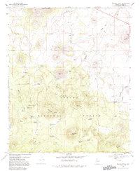
1969 Map of Whiting Knoll
USGS Topo · Published 1992About this map
Apache National Forest dominates this highland landscape, where volcanic peaks and cinder cones punctuate the high-altitude terrain. The map records several high-country residences and family sites, notably the Whiting Homestead and Red Cabin, providing a specific record of land use before the late 20th century. Water management is central to the area's utility, marked by a network of tanks and springs like Halls Tank No 1, Mallory Spring, and Little Giant Spring.
Find a feature on this map
48 named features on this map. Tap any name to fly to it.
Don’t see what you’re looking for? This feature index may not catch every label — zoom into the map to look around manually.
Map Details
Editions of this 1969 Whiting Knoll Map
Other maps of this area

1886 · St Johns
USGS Topo · 1:250,000

1892 · St Johns
USGS Topo · 1:250,000

1954 · Saint Johns
USGS Topo · 1:250,000

1957 · Saint Johns
USGS Topo · 1:250,000

1958 · Saint Johns
USGS Topo · 1:250,000

1962 · Saint Johns
USGS Topo · 1:250,000

1968 · Boundary Butte
USGS Topo · 1:24,000

1968 · Springerville NW
USGS Topo · 1:24,000

1969 · Whiting Knoll
USGS Topo · 1:24,000
1969 · Greer
USGS Topo · 1:24,000