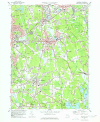
1977 Map of Whitman
USGS Topo · Published 1978About this map
Whitman and the surrounding townships in Plymouth County reveal a densely settled landscape shaped by a sophisticated hydrological network. The Shumatuscacant River and Satucket River wind through the interior, feeding numerous ponds such as Hobart Pond and Forge Pond. This late-1970s landscape is characterized by its transition from industrial centers to suburban residential clusters, with the Conrail lines providing a backbone for commerce through Abington and East Bridgewater.
Find a feature on this map
145 named features on this map. Tap any name to fly to it.
Don’t see what you’re looking for? This feature index may not catch every label — zoom into the map to look around manually.
Map Details
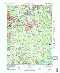
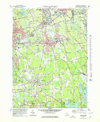
Editions of this 1977 Whitman Map
4 editions found

Other maps of this area

1885 · Abington
USGS Topo · 1:62,500

1885 · Middleboro
USGS Topo · 1:62,500

1885 · Taunton
USGS Topo · 1:62,500

1886 · Dedham
USGS Topo · 1:62,500

1888 · Taunton
USGS Topo · 1:62,500

1888 · Middleboro
USGS Topo · 1:62,500

1888 · Abington
USGS Topo · 1:62,500

1893 · Abington
USGS Topo · 1:62,500

1893 · Taunton
USGS Topo · 1:62,500

1893 · Middleboro
USGS Topo · 1:62,500