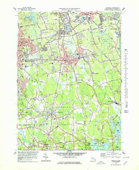
1977 Map of Whitman
USGS Topo · Published 1979About this map
Ames Nowell State Park and Cleveland Pond anchor the northwestern corner of this Plymouth County landscape, where the residential expansion of Brockton meets the established town centers of Whitman, Abington, and Rockland. The 1970s terrain is defined by a dense network of suburban streets and institutional landmarks, including Massasoit College and Spellman Central High Sch. Waterways like the Shumatuscacant River and Satucket River wind through the region, connecting smaller hamlets such as Elmwood, Westdale, and Eastville.
Find a feature on this map
135 named features on this map. Tap any name to fly to it.
Don’t see what you’re looking for? This feature index may not catch every label — zoom into the map to look around manually.
Map Details
Editions of this 1977 Whitman Map
4 editions found
Other maps of this area

1885 · Abington
USGS Topo · 1:62,500

1885 · Middleboro
USGS Topo · 1:62,500

1885 · Taunton
USGS Topo · 1:62,500

1886 · Dedham
USGS Topo · 1:62,500

1888 · Taunton
USGS Topo · 1:62,500

1888 · Middleboro
USGS Topo · 1:62,500

1888 · Abington
USGS Topo · 1:62,500

1893 · Abington
USGS Topo · 1:62,500

1893 · Taunton
USGS Topo · 1:62,500

1893 · Middleboro
USGS Topo · 1:62,500