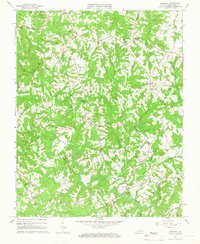
1965 Map of Whitmell
USGS Topo · Published 1966About this map
Swansonville and Hinesville anchor a mid-1960s landscape in Pittsylvania County, characterized by a dense network of rural churches and family-named landmarks. The terrain is deeply carved by the Sandy River and its numerous tributaries, including Stewart Creek and Sugartree Creek, which dictated the winding paths of the local road system before significant modernization. Communities such as Whitmell and Stony Mill appear here as established local hubs, with Tunstall High Sch and Stony Mill Sch serving the surrounding countryside.
Find a feature on this map
39 named features on this map. Tap any name to fly to it.
Don’t see what you’re looking for? This feature index may not catch every label — zoom into the map to look around manually.
Map Details
Editions of this 1965 Whitmell Map
2 editions found
Other maps of this area

1921 · Chatham
USGS Topo · 1:48,000

1922 · Callands
USGS Topo · 1:48,000

1923 · Danville
USGS Topo · 1:48,000

1923 · Chatham
USGS Topo · 1:62,500

1924 · Draper
USGS Topo · 1:48,000

1924 · Callands
USGS Topo · 1:62,500

1925 · Danville
USGS Topo · 1:62,500

1926 · Draper
USGS Topo · 1:62,500

1944 · Draper
USGS Topo · 1:62,500

1944 · Callands
USGS Topo · 1:62,500