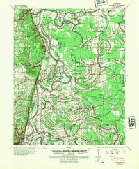
1940 Map of Whitmore
USGS Topo · Published 1954About this map
The St Francis River dominates this 1940 topographic landscape, carving deep meanders and creating complex landforms like Wittsburg Island and Bay Ferry Bend. The river’s influence is evident in the numerous oxbow lakes and sloughs, including Grassy Lake, Yancopin Lake, and Shell Lake, which define the low-lying terrain. Settled clusters like Wittsburg, Whitmore, and Widener anchor the local geography, while the Old Military Road and Butler Channel Road indicate established overland routes through the bottomlands.
Find a feature on this map
121 named features on this map. Tap any name to fly to it.
Don’t see what you’re looking for? This feature index may not catch every label — zoom into the map to look around manually.
Map Details
Editions of this 1940 Whitmore Map
2 editions found
Other maps of this area

1931 · Horseshoe Lake
USGS Topo · 1:62,500

1939 · Vanndale
USGS Topo · 1:62,500

1939 · Horseshoe Lake
USGS Topo · 1:62,500

1939 · Park Place
USGS Topo · 1:62,500

1939 · Wynne
USGS Topo · 1:62,500

1939 · Edmondson
USGS Topo · 1:62,500

1940 · Deckerville
USGS Topo · 1:62,500

1940 · Princedale
USGS Topo · 1:62,500

1940 · Whitmore
USGS Topo · 1:62,500

1940 · Marianna
USGS Topo · 1:62,500