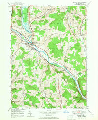
1949 Map of Whitney Point
USGS Topo · Published 1976About this map
The confluence of the Otselic River and the Tioughnioga River serves as the focal point for this Broome County landscape, which is defined by a sophisticated flood management system. The prominent Whitney Point Flood Control Dam was established by the 1940s to protect the downstream communities of Whitney Point and Lisle. These settlements are closely tied to the transport corridors that follow the river valleys, including the Delaware Lackawanna and Western Railroad and the historic Catskill and Western Turnpike.
Find a feature on this map
43 named features on this map. Tap any name to fly to it.
Don’t see what you’re looking for? This feature index may not catch every label — zoom into the map to look around manually.
Map Details
Editions of this 1949 Whitney Point Map
3 editions found
Other maps of this area

1901 · Apalachin
USGS Topo · 1:62,500

1903 · Harford
USGS Topo · 1:62,500

1904 · Binghamton
USGS Topo · 1:62,500

1904 · Greene
USGS Topo · 1:62,500

1904 · Apalachin
USGS Topo · 1:62,500

1906 · Catatonk
USGS Topo · 1:125,000

1934 · Castle Creek
USGS Topo · 1:24,000

1935 · Chenango Forks
USGS Topo · 1:24,000

1942 · Castle Creek
USGS Topo · 1:31,680

1942 · Chenango Forks
USGS Topo · 1:31,680