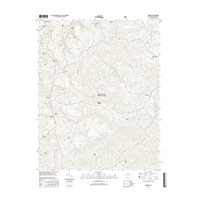
2016 Map of Wiborg
USGS Topo · Published 2016About this map
Daniel Boone National Forest dominates this McCreary County landscape, where deep drainages like Dead Man Hollow and Patterson Hollow define the area's geography. The settlement of Beulah Heights sits at the center of the sheet, connected to nearby Wiborg and Flat Rock along the ridge-running routes. Genealogy researchers will find several family and community burial grounds, including Hughes Cem, Piney Grove Cem, and Hickenbottom Cem near the winding waters of Indian Creek. The terrain is characterized by prominent high points such as Taylor Ridge and Big Swag Ridge, which separate the various forks of Eagle Cr and Freeman Fork. This map captures a modern view of a region historically tied to the timber and mining economies of the Cumberland Plateau, evidenced by the numerous named hollows and secondary ridges that provided access to the land's resources.
Find a feature on this map
49 named features on this map. Tap any name to fly to it.
Don’t see what you’re looking for? This feature index may not catch every label — zoom into the map to look around manually.
Map Details
Editions of this 2016 Wiborg Map
This is the sole edition of this map. No revisions or reprints were ever made.
Other maps of this area

1890 · Williamsburg
USGS Topo · 1:125,000

1894 · Williamsburg
USGS Topo · 1:125,000

1932 · Burnside
USGS Topo · 1:62,500

1934 · Barthell
USGS Topo · 1:62,500

1952 · Hail
USGS Topo · 1:24,000

1952 · Hollyhill
USGS Topo · 1:24,000

1952 · Wiborg
USGS Topo · 1:24,000

1952 · Cumberland Falls
USGS Topo · 1:24,000

1952 · Whitley City
USGS Topo · 1:24,000
1952 · Sawyer
USGS Topo · 1:24,000