
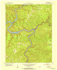
1952 Map of Wiborg
USGS Topo · Published 1954About this map
Cumberland National Forest dominates this McCreary County landscape, where the Southern railroad line snakes through the western hills, connecting the settlements of Greenwood, Wiborg, and Parkers Lake. The terrain is characterized by deep ravines and narrow ridges, such as Middle Ridge and Taylor Ridge, where human activity centers on small clusters of mountain churches and schools. Local heritage is preserved in the locations of Noah Chapel and Roberts Chapel, as well as the Sand Hill School and Vanover School. The map reveals a reliance on traditional infrastructure, including a prominent telephone line following the main north-south road corridor. Water sources are abundant, with numerous branches like Eagle Creek and Indian Creek carving through the plateau, reflecting a way of life deeply integrated into the hollows and flats of the Kentucky wilderness.
Find a feature on this map
53 named features on this map. Tap any name to fly to it.
Don’t see what you’re looking for? This feature index may not catch every label — zoom into the map to look around manually.
Map Details
Editions of this 1952 Wiborg Map
This is the sole edition of this map. No revisions or reprints were ever made.
Other maps of this area

1890 · Williamsburg
USGS Topo · 1:125,000

1894 · Williamsburg
USGS Topo · 1:125,000

1932 · Burnside
USGS Topo · 1:62,500

1934 · Barthell
USGS Topo · 1:62,500

1952 · Hail
USGS Topo · 1:24,000

1952 · Hollyhill
USGS Topo · 1:24,000

1952 · Cumberland Falls
USGS Topo · 1:24,000

1952 · Whitley City
USGS Topo · 1:24,000
1952 · Sawyer
USGS Topo · 1:24,000

1954 · Burnside
USGS Topo · 1:24,000