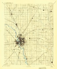
1955 Map of Wichita
USGS Topo · Published 1959This historical map portrays the area of Wichita in 1955, primarily covering Sedgwick County as well as portions of Elk County, Cowley County, Harvey County, Kingman County, Sumner County, Greenwood County, Harper County, Butler County, Reno County, and Chautauqua County. Featuring a scale of 1:250000, this map provides a highly detailed snapshot of the terrain, roads, buildings, counties, and historical landmarks in the Wichita region at the time. Published in 1959, it is one of 3 known editions of this map due to revisions or reprints.
Find a feature on this map
239 named features on this map. Tap any name to fly to it.
Don’t see what you’re looking for? This feature index may not catch every label — zoom into the map to look around manually.
Map Details
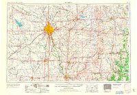
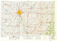
Editions of this 1955 Wichita Map
3 editions found
Historical Maps of Rocky Ford Through Time
6 maps found