
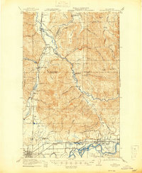
1921 Map of Wickersham
USGS Topo · Published 1921About this map
Sedro Woolley and the industrial corridors of the Skagit Valley define this early twentieth-century survey. The landscape is marked by a transition from the agricultural lowlands of Ross Island and the Skagit River to the timbered heights of Blue Mountain and Anderson Mountain. Evidence of the region’s resource-driven economy is everywhere, from the Cokedale Mine and its namesake Cokedale Junction to the several railroads like the Northern Pacific RR and Great Northern Ry that facilitated transport through the valley. Small community hubs like Wickersham and Lyman serve as anchor points for rural life, supported by a network of local institutions including the Utopia School and Tingley School. Further north, the survey tracks the Samish River and the rugged transition into the Washington National Forest, where isolated outposts like Scott Cabin and Ives Ranch stand as remote landmarks.
Find a feature on this map
59 named features on this map. Tap any name to fly to it.
Don’t see what you’re looking for? This feature index may not catch every label — zoom into the map to look around manually.
Map Details
Editions of this 1921 Wickersham Map
2 editions found
Other maps of this area

1899 · Stillaguamish
USGS Topo · 1:125,000

1901 · Stilaguamish
USGS Topo · 1:125,000

1906 · Sumas
USGS Topo · 1:62,500

1908 · Sumas
USGS Topo · 1:62,500

1909 · Mt Baker
USGS Topo · 1:192,000

1911 · Mount Vernon
USGS Topo · 1:125,000

1915 · Mt. Baker
USGS Topo · 1:250,000

1918 · Samish Lake
USGS Topo · 1:62,500

1919 · Van Zandt
USGS Topo · 1:62,500

1940 · Mt Vernon
USGS Topo · 1:62,500