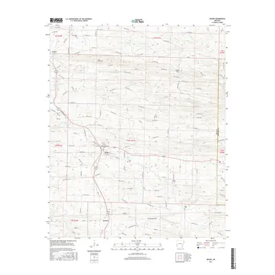
2017 Map of Wickes
USGS Topo · Published 2017About this map
Wickes and Grannis serve as the primary hubs in this western Arkansas landscape, situated along a north-south transportation corridor that follows the lower elevations between the Cross Mountains and the Polk Co Howard Co boundary. The terrain is defined by a dense network of creek drainages, including the Rolling Fork, Pryor Cr, and Opossum Cr, which carve through the ridges. The distribution of family and community burial grounds, such as Witherspoon Cem, Daniel Cem, and Crystal Hill Cem, provides significant geographic markers for local family history and genealogy. Outside the main settlements, the land is etched with numerous forest roads and local routes like Polk Road 13 and Hatton Ln, leading toward landmarks like Bradley Gap and the waters of Brewer Lake.
Find a feature on this map
107 named features on this map. Tap any name to fly to it.
Don’t see what you’re looking for? This feature index may not catch every label — zoom into the map to look around manually.
Map Details
Editions of this 2017 Wickes Map
This is the sole edition of this map. No revisions or reprints were ever made.
Other maps of this area

1913 · De Queen
USGS Topo · 1:125,000

1950 · Mcalester
USGS Topo · 1:250,000

1959 · Umpire
USGS Topo · 1:62,500

1959 · Cove
USGS Topo · 1:62,500

1962 · McAlester
USGS Topo · 1:250,000

1964 · Gillham Dam
USGS Topo · 1:24,000

1964 · Gillham
USGS Topo · 1:24,000

1965 · McAlester
USGS Topo · 1:250,000
1966 · De Queen NW
USGS Topo · 1:24,000
1984 · Vandervoort
USGS Topo · 1:24,000