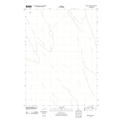
2010 Map of Wickiup Creek
USGS Topo · Published 2010About this map
Rose Ridge overlooks a series of drainages in this corner of Owyhee County, defining the northern landscape where Rose Creek and Combination Creek originate. The area is characterized by a network of seasonal watercourses and valley systems, notably the long stretches of Anne Valley Creek and Pleasant Valley Creek that cut across the central and southern portions of the terrain. This drainage pattern reflects the arid, high-desert environment of southern Idaho, where water flow is dictated by the local topography. Further east, the namesake Wickiup Creek and the meandering Josephine Creek dominate the hydrography. The presence of features like Nip and Tuck Creek and Crooked Creek suggests a landscape of complex, winding draws and natural catchment areas, largely devoid of modern development or permanent structures in the early 21st century.
Find a feature on this map
10 named features on this map. Tap any name to fly to it.
Don’t see what you’re looking for? This feature index may not catch every label — zoom into the map to look around manually.
Map Details
Editions of this 2010 Wickiup Creek Map
This is the sole edition of this map. No revisions or reprints were ever made.
Other maps of this area

1955 · Jordan Valley
USGS Topo · 1:250,000

1957 · Jordan Valley
USGS Topo · 1:250,000

1958 · Jordan Valley
USGS Topo · 1:250,000

1965 · Triangle
USGS Topo · 1:62,500

1965 · Flint Creek
USGS Topo · 1:62,500
1973 · Wagon Box Basin
USGS Topo · 1:24,000

1973 · Indian Meadows
USGS Topo · 1:24,000

1973 · Hurry Up Creek
USGS Topo · 1:24,000

1973 · Pleasant Valley
USGS Topo · 1:24,000

1973 · Wickiup Creek
USGS Topo · 1:24,000