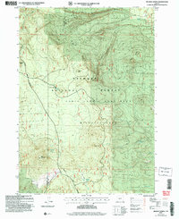
2004 Map of Wickiup Spring
USGS Topo · Published 2007About this map
Fremont National Forest dominates this volcanic landscape, where the high desert terrain is defined by prominent peaks and a sparse network of water sources. The map highlights the essential role of springs in this arid region, from the centrally located Wickiup Spring to the more remote Mush Spring and Timothy Spring in the south. These water points often dictated the movement of wildlife and early land use, particularly around the Cabin Lake Wildlife Area.
Find a feature on this map
18 named features on this map. Tap any name to fly to it.
Don’t see what you’re looking for? This feature index may not catch every label — zoom into the map to look around manually.
Map Details
Editions of this 2004 Wickiup Spring Map
This is the sole edition of this map. No revisions or reprints were ever made.
Other maps of this area

1955 · Crescent
USGS Topo · 1:250,000

1957 · Crescent
USGS Topo · 1:250,000

1958 · Crescent
USGS Topo · 1:250,000

1968 · Location Butte
USGS Topo · 1:24,000

1968 · Oatman Flat
USGS Topo · 1:24,000
1968 · Antelope Mtn
USGS Topo · 1:24,000

1970 · Crescent
USGS Topo · 1:250,000

1979 · Crescent
USGS Topo · 1:100,000
1981 · Wickiup Spring
USGS Topo · 1:24,000
1981 · Stams Mtn
USGS Topo · 1:24,000