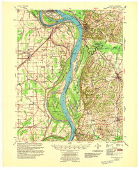
1955 Map of Wickliffe
USGS Topo · Published 1955About this map
The confluence of the Ohio River and Mississippi River dominates this mid-century survey, illustrating a landscape defined by shifting water and river commerce. This crucial junction, where the waters meet near Cairo, Illinois, and Wickliffe, Kentucky, is marked by a complex system of river engineering including the Bend Revetment and a series of landings such as Norfolk Ldg and Pritchard Ldg. The terrain is a mosaic of islands and backwaters like Cane Island and Flat Pond, showing how the river's movement shaped local geography and travel during the era of flood control expansion.
Find a feature on this map
91 named features on this map. Tap any name to fly to it.
Don’t see what you’re looking for? This feature index may not catch every label — zoom into the map to look around manually.
Map Details
Editions of this 1955 Wickliffe Map
This is the sole edition of this map. No revisions or reprints were ever made.
Other maps of this area

1928 · La Center
USGS Topo · 1:62,500

1931 · Cairo
USGS Topo · 1:62,500

1932 · La Center
USGS Topo · 1:62,500

1933 · Cairo
USGS Topo · 1:62,500

1934 · Thebes
USGS Topo · 1:62,500

1939 · Wickliffe
USGS Topo · 1:62,500

1939 · Charleston
USGS Topo · 1:62,500

1939 · Hickman
USGS Topo · 1:62,500

1939 · Bayouville
USGS Topo · 1:62,500

1939 · Cairo
USGS Topo · 1:62,500