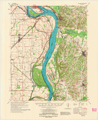
1972 Map of Wickliffe
USGS Topo · Published 1972About this map
The confluence of the Ohio River and Mississippi River dominates this 1972 survey, capturing the complex hydraulic landscape where Kentucky, Missouri, and Illinois meet. Significant state landmarks like Fort Defiance State Park and Columbus-Belmont State Park anchor the river bluffs, while the lowlands are defined by an intricate network of levees and river features like the Chute of Islands 2, 3 & 4 and Angelo Towhead. The region’s rail history is well-represented, showing the Illinois Central Gulf and Louisville & Nashville lines serving river towns like Wickliffe and Cairo. Genealogists will find numerous family-named burial sites including Harrison-Hughes Cem and Griggs Cem, alongside small rural congregations at Beech Grove Ch and Webbs Chapel that mark the established farming communities of Ballard, Carlisle, and Hickman counties.
Find a feature on this map
69 named features on this map. Tap any name to fly to it.
Don’t see what you’re looking for? This feature index may not catch every label — zoom into the map to look around manually.
Map Details
Editions of this 1972 Wickliffe Map
This is the sole edition of this map. No revisions or reprints were ever made.
Other maps of this area

1928 · La Center
USGS Topo · 1:62,500

1931 · Cairo
USGS Topo · 1:62,500

1932 · La Center
USGS Topo · 1:62,500

1933 · Cairo
USGS Topo · 1:62,500

1934 · Thebes
USGS Topo · 1:62,500

1939 · Wickliffe
USGS Topo · 1:62,500

1939 · Charleston
USGS Topo · 1:62,500

1939 · Hickman
USGS Topo · 1:62,500

1939 · Bayouville
USGS Topo · 1:62,500

1939 · Cairo
USGS Topo · 1:62,500