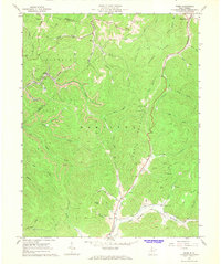
1967 Map of Widen
USGS Topo · Published 1968About this map
Coal extraction and rugged topography define this 1967 survey of the border between Nicholas and Clay counties. The company town of Widen is a central focal point, showing the industrial infrastructure of the era including a Tipple, a Substation, and numerous Strip Mine operations carved into the hillsides. The landscape is a complex network of narrow hollows and high ridges like Powell Mountain and Browns Ridge, where small settlements like Wattsville and Dille cling to the limited level ground near Buffalo Creek.
Find a feature on this map
63 named features on this map. Tap any name to fly to it.
Don’t see what you’re looking for? This feature index may not catch every label — zoom into the map to look around manually.
Map Details
Editions of this 1967 Widen Map
2 editions found
Other maps of this area

1889 · Nicholas
USGS Topo · 1:125,000

1891 · Nicholas
USGS Topo · 1:125,000

1893 · Sutton
USGS Topo · 1:125,000

1901 · Nicholas
USGS Topo · 1:125,000

1908 · Gassaway
USGS Topo · 1:48,000

1908 · Sutton
USGS Topo · 1:48,000

1910 · Sutton Special
USGS Topo · 1:62,500

1910 · Gassaway
USGS Topo · 1:62,500

1913 · Summersville
USGS Topo · 1:48,000

1915 · Cowen
USGS Topo · 1:48,000