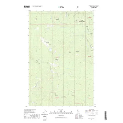
2020 Map of Widow Mountain
USGS Topo · Published 2020About this map
St. Joe National Forest encompasses this high-elevation landscape in Shoshone County, where the Little N Fork Clearwater River and its numerous tributaries like Lund Cr and Delaney Cr carve through the Idaho backcountry. A historic Splash Dam on Marble Cr points to early twentieth-century logging practices when the river network served as the primary transport for timber. The terrain is defined by a series of prominent summits including Widow Mtn, Crater Peak, and Lookout Mtn. Small alpine water bodies such as Crow Lake, Lost Lake, and Crater Lake are scattered across the high basins, while Pinchot Marsh marks a significant wetland area in the southern reaches. Numerous forest roads and trails, including St Joe NF Rd 301 and the Delaney Creek Nrt, provide the only access through this complex drainage system.
Find a feature on this map
49 named features on this map. Tap any name to fly to it.
Don’t see what you’re looking for? This feature index may not catch every label — zoom into the map to look around manually.
Map Details
Editions of this 2020 Widow Mountain Map
This is the sole edition of this map. No revisions or reprints were ever made.
Other maps of this area

1914 · Avery
USGS Topo · 1:125,000

1917 · Avery
USGS Topo · 1:125,000

1923 · Washington Creek
USGS Topo · 1:125,000

1936 · Boehls Butte
USGS Topo · 1:48,000

1943 · Boehls Butte
USGS Topo · 1:62,500

1955 · Pullman
USGS Topo · 1:250,000

1955 · Spokane
USGS Topo · 1:250,000

1956 · Wallace
USGS Topo · 1:250,000

1956 · Hamilton
USGS Topo · 1:250,000

1958 · Spokane
USGS Topo · 1:250,000