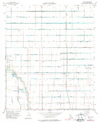
1956 Map of Wiest
USGS Topo · Published 1987About this map
The Alamo River meanders through this portion of the Imperial Valley, defining a landscape of intensive desert irrigation. A dense network of engineered waterways, including the Vail Supply Canal and alphabetical and botanical systems like the Nectarine Lateral Drain, Narcissus Lateral Drain, and Magnolia Lateral Drain, reveals the transformation of this arid region into productive farmland. The map captures small rural centers such as Wiest and Butters, alongside local institutions like the Mulberry School. Along the river's western banks, the Imperial Waterfowl Management Area and Wiest Lake show the importance of water management for both agriculture and conservation. Family-named landmarks such as Gieselmann Lake and a grid of roads including Blair Road and Brownell Road provide valuable geographic markers for those tracing the development and land-use patterns of the mid-20th-century California desert.
Find a feature on this map
40 named features on this map. Tap any name to fly to it.
Don’t see what you’re looking for? This feature index may not catch every label — zoom into the map to look around manually.
Map Details
Editions of this 1956 Wiest Map
3 editions found
Other maps of this area

1907 · Holtville
USGS Topo · 1:125,000

1915 · El Centro
USGS Topo · 1:125,000

1940 · Brawley
USGS Topo · 1:62,500

1940 · Iris
USGS Topo · 1:62,500

1940 · Alamorio
USGS Topo · 1:62,500

1942 · El Centro
USGS Topo · 1:250,000

1943 · Brawley
USGS Topo · 1:62,500

1944 · Calipatria
USGS Topo · 1:62,500

1945 · Alamorio
USGS Topo · 1:62,500

1945 · Iris
USGS Topo · 1:62,500