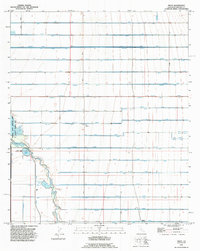
1992 Map of Wiest
USGS Topo · Published 1995About this map
The settlement of Wiest sits at the heart of an meticulously engineered irrigation landscape in Imperial County, California. This 1990s revision reflects decades of agricultural development, where a grid of alphabetized and botanical-named canals like Nectarine Lateral, Narcissus Lateral, and Munyon Lateral distribute water across the desert floor. The Alamo River meanders through the southern half of the quadrangle, providing a sharp contrast to the rigid linear patterns of the surrounding crop fields and drainage ditches. Recreation and conservation are anchored by the Imperial State Wildlife Area (Finney-Ramer Unit), which encompasses Finney Lake and Sheldon Pond, while the Wiest Lake County Park offers a concentrated hub of local activity centered around Wiest Lake. The map reveals the intricate water management system essential for this region's productivity, from the Vail Supply Canal to smaller works like the Mulberry Drain.
Find a feature on this map
56 named features on this map. Tap any name to fly to it.
Don’t see what you’re looking for? This feature index may not catch every label — zoom into the map to look around manually.
Map Details
Editions of this 1992 Wiest Map
This is the sole edition of this map. No revisions or reprints were ever made.
Other maps of this area

1907 · Holtville
USGS Topo · 1:125,000

1915 · El Centro
USGS Topo · 1:125,000

1940 · Brawley
USGS Topo · 1:62,500

1940 · Iris
USGS Topo · 1:62,500

1940 · Alamorio
USGS Topo · 1:62,500

1942 · El Centro
USGS Topo · 1:250,000

1943 · Brawley
USGS Topo · 1:62,500

1944 · Calipatria
USGS Topo · 1:62,500

1945 · Alamorio
USGS Topo · 1:62,500

1945 · Iris
USGS Topo · 1:62,500