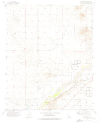
1973 Map of Wild Crossing
USGS Topo · Published 1976About this map
Wild Crossing and Point of Rocks sit along the banks of the Mojave River, marking a critical juncture of desert transit in the early 1970s. The landscape is defined by the infrastructure of the Atchison Topeka and Santa Fe Railroad and the National Trails Highway, which follow the river's natural corridor. To the north, the terrain rises toward Iron Mountain, while the desert floor is crisscrossed by specialized routes like Brisbane Pipeline Road and the historic Santa Fe Trail. Aviation and industrial needs are evident through the Helendale Airport, a mid-century Landing Strip, and several Gravel Pits and Borrow Pits. The presence of North Lake and numerous Wells highlight the importance of water management in this arid San Bernardino County environment.
Find a feature on this map
32 named features on this map. Tap any name to fly to it.
Don’t see what you’re looking for? This feature index may not catch every label — zoom into the map to look around manually.
Map Details
Editions of this 1973 Wild Crossing Map
2 editions found
Other maps of this area

1932 · Barstow
USGS Topo · 1:125,000

1934 · Barstow
USGS Topo · 1:125,000

1953 · San Bernardino
USGS Topo · 1:250,000

1956 · San Bernardino
USGS Topo · 1:250,000

1956 · Hawes
USGS Topo · 1:62,500
1956 · Victorville NW
USGS Topo · 1:24,000

1956 · Barstow
USGS Topo · 1:62,500

1956 · Helendale
USGS Topo · 1:24,000
1956 · Victorville
USGS Topo · 1:62,500

1957 · Apple Valley
USGS Topo · 1:62,500