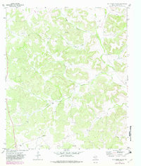
1969 Map of Wild Horse Canyon
USGS Topo · Published 1982About this map
Isolated family outposts like Ward Ranch and Skelton Ranch define the settlement pattern of this West Texas landscape during the late 1960s. The terrain is deeply incised by a network of ephemeral watercourses including Wild Horse Canyon, Little Shaggy Canyon, and Taylor Box Draw, which channel runoff through the limestone plateaus. Evidence of the region’s economic reliance on ranching and energy extraction is scattered throughout the draws, noted by several Gas Well locations, a Sulphur Windmill, and a remote Landing Strip used for transportation across the expansive distances.
Find a feature on this map
20 named features on this map. Tap any name to fly to it.
Don’t see what you’re looking for? This feature index may not catch every label — zoom into the map to look around manually.
Map Details
Editions of this 1969 Wild Horse Canyon Map
2 editions found
Other maps of this area

1954 · Sonora
USGS Topo · 1:250,000

1958 · Sonora
USGS Topo · 1:250,000

1967 · Baggett Ranch
USGS Topo · 1:24,000

1967 · Flat Rock Draw SW
USGS Topo · 1:24,000

1967 · Ozona SE
USGS Topo · 1:24,000

1967 · Shafter Draw
USGS Topo · 1:24,000
1967 · Hospital Ranch
USGS Topo · 1:24,000

1969 · Wild Horse Canyon
USGS Topo · 1:24,000

1970 · Indian Draw
USGS Topo · 1:24,000

1970 · Brushy Draw
USGS Topo · 1:24,000