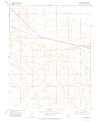
1978 Map of Wild Horse
USGS Topo · Published 1978About this map
Wild Horse serves as the primary landmark in this late 1970s Cheyenne County survey, situated along the Union Pacific railroad corridor. The settlement is defined by its relationship to the iron rail and the path of Big Sandy Creek, which weaves through the central portion of the sheet. Notable local infrastructure includes the Wild Horse Cem and several Landing Strips, reflecting the region's reliance on both traditional rail transport and aviation for connectivity across the high plains.
Find a feature on this map
12 named features on this map. Tap any name to fly to it.
Don’t see what you’re looking for? This feature index may not catch every label — zoom into the map to look around manually.
Map Details
Editions of this 1978 Wild Horse Map
This is the sole edition of this map. No revisions or reprints were ever made.
Other maps of this area

1891 · Arroyo
USGS Topo · 1:125,000

1891 · Kit Carson
USGS Topo · 1:125,000

1893 · Arroyo
USGS Topo · 1:125,000

1893 · Kit Carson
USGS Topo · 1:125,000

1954 · Lamar
USGS Topo · 1:250,000

1958 · Lamar
USGS Topo · 1:250,000

1978 · Galatea NE
USGS Topo · 1:24,000

1978 · Aroya
USGS Topo · 1:24,000

1978 · Sanders Ranch
USGS Topo · 1:24,000

1978 · Stacy Lakes Draw
USGS Topo · 1:24,000