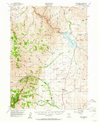
1956 Map of Wild Horse
USGS Topo · Published 1961About this map
McAfee Peak and the high ridges of the Independence Mountains dominate this mid-century survey of northeastern Nevada. The landscape is defined by the headwaters of the Owyhee River and the Humboldt River, which feed the prominent Wild Horse Reservoir. While the Humboldt National Forest covers much of the high ground, the valley floors are dotted with remote outposts of ranching life, such as Vega Ranch, Doheny Ranch, and Spring Creek Ranch. These private holdings, along with the Harrison School, suggest a self-sufficient community structured around high-desert livestock and water management. Transportation is limited to a network of primitive routes, including several labeled Jeep Trails, a Landing Strip, and the historic Wild Horse Crossing. Resource management is evident through features like the North Fork Guard Sta and the Spillway 6189 at the reservoir, reflecting the federal and state efforts to manage this arid terrain for both forest preservation and agricultural use.
Find a feature on this map
73 named features on this map. Tap any name to fly to it.
Don’t see what you’re looking for? This feature index may not catch every label — zoom into the map to look around manually.
Map Details
Editions of this 1956 Wild Horse Map
3 editions found

Other maps of this area

1935 · Charleston
USGS Topo · 1:48,000

1936 · Mountain City
USGS Topo · 1:62,500

1936 · Rowland
USGS Topo · 1:48,000

1939 · Owyhee
USGS Topo · 1:62,500

1940 · Rowland
USGS Topo · 1:62,500

1940 · Mountain City
USGS Topo · 1:62,500

1942 · Owyhee
USGS Topo · 1:62,500

1942 · Mt. Velma
USGS Topo · 1:62,500

1955 · McDermitt
USGS Topo · 1:250,000

1955 · Wells
USGS Topo · 1:250,000