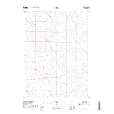
2017 Map of Wild Horse Hill
USGS Topo · Published 2017About this map
Wild Horse Hill stands as a central landmark in this high-plains landscape of Washakie County, where water management and livestock movement define the local geography. The winding course of the Nowood River and its tributary, Brokenback Cr, dictate the flow of the terrain, while man-made interventions like The W Ditch and the Big Cottonwood Reservoir highlight the region's reliance on irrigation and water storage. Historical transportation routes, including the Old Ten Sleep Hwy and the Tensleep Hyattville Rd, provide evidence of the long-standing connections between rural ranching communities. The presence of the W T Stock Driveway further emphasizes the enduring ranching heritage of the area, marking traditional paths used for moving cattle across the basin. From the elevations of Blue Ridge to the depths of Red Gulch and Meyers Gulch, the map details a complex network of ridges and drainages shaped by both natural erosion and human industry.
Find a feature on this map
21 named features on this map. Tap any name to fly to it.
Don’t see what you’re looking for? This feature index may not catch every label — zoom into the map to look around manually.
Map Details
Editions of this 2017 Wild Horse Hill Map
This is the sole edition of this map. No revisions or reprints were ever made.
Other maps of this area

1899 · Cloud peak
USGS Topo · 1:125,000

1901 · Cloud Peak
USGS Topo · 1:125,000

1955 · Sheridan
USGS Topo · 1:250,000

1955 · Arminto
USGS Topo · 1:250,000

1958 · Sheridan
USGS Topo · 1:250,000

1958 · Arminto
USGS Topo · 1:250,000

1962 · Sheridan
USGS Topo · 1:250,000

1962 · Arminto
USGS Topo · 1:250,000

1966 · Cabin Fork
USGS Topo · 1:24,000
1966 · Joe Emge Creek
USGS Topo · 1:24,000