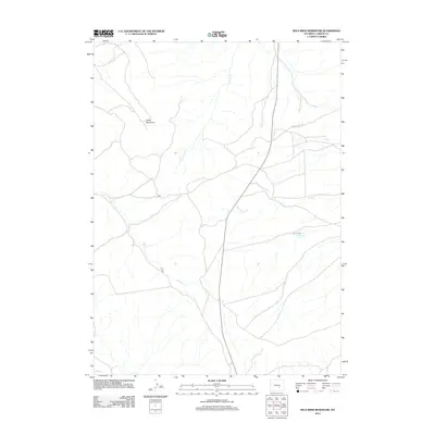
2012 Map of Wild Irish Reservoir
USGS Topo · Published 2012About this map
Wild Irish Reservoir sits at the heart of this high-plains landscape in Carbon County, where a complex network of ephemeral drainage channels defines the local topography. This 2012 survey documents a sparsely populated ranching environment centered around the prominence of Chalk Mountain. Human activity is primarily traced through the infrastructure of high-country transit, most notably along Shirley Ridge Rd and the various unnamed access tracks that traverse the grazing lands. The hydrology of the region is characterized by seasonal waterways including Stinking Cr, Sand Cr, and Dry Cr, all of which feed into the larger system of Muddy Cr in the south. These features illustrate the vital role of water management and natural catchment in Wyoming’s arid interior during the early 21st century.
Find a feature on this map
7 named features on this map. Tap any name to fly to it.
Don’t see what you’re looking for? This feature index may not catch every label — zoom into the map to look around manually.
Map Details
Editions of this 2012 Wild Irish Reservoir Map
This is the sole edition of this map. No revisions or reprints were ever made.
Other maps of this area

1951 · Bear Mountain
USGS Topo · 1:24,000

1953 · Fourmile Point
USGS Topo · 1:24,000

1953 · The Q Ranch
USGS Topo · 1:24,000

1955 · Casper
USGS Topo · 1:250,000

1958 · Casper
USGS Topo · 1:250,000

1960 · Wild Irish Reservoir
USGS Topo · 1:24,000

1960 · Horse Peak
USGS Topo · 1:24,000

1960 · Mud Springs
USGS Topo · 1:24,000

1960 · Measel Spring Reservoir
USGS Topo · 1:24,000
1961 · Pine Hill
USGS Topo · 1:24,000