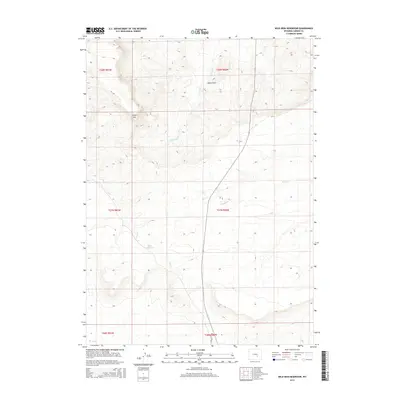
2015 Map of Wild Irish Reservoir
USGS Topo · Published 2015About this map
Bates Hole defines the northeastern portion of this Carbon County landscape, where the high plains of Wyoming are deeply etched by intermittent drainages. The area is characterized by a sparse network of water features including Stinking Cr and Sand Cr, which cut through the high-elevation terrain near Chalk Mtn. Human presence in this section of the Shirley Basin is marked primarily by infrastructure designed for water management and transportation, most notably Miles Reservoir in the central western section and the corridor of the Shirley Basin Rd. This 2015 survey illustrates a landscape primarily shaped by cattle ranching and resource management, where surveyed township lines like T27N R80W organize a territory that appears otherwise open and untamed. The presence of Muddy Cr at the southern edge further emphasizes the seasonal importance of water in this arid Wyoming environment.
Find a feature on this map
15 named features on this map. Tap any name to fly to it.
Don’t see what you’re looking for? This feature index may not catch every label — zoom into the map to look around manually.
Map Details
Editions of this 2015 Wild Irish Reservoir Map
This is the sole edition of this map. No revisions or reprints were ever made.
Other maps of this area

1951 · Bear Mountain
USGS Topo · 1:24,000

1953 · Fourmile Point
USGS Topo · 1:24,000

1953 · The Q Ranch
USGS Topo · 1:24,000

1955 · Casper
USGS Topo · 1:250,000

1958 · Casper
USGS Topo · 1:250,000

1960 · Wild Irish Reservoir
USGS Topo · 1:24,000

1960 · Horse Peak
USGS Topo · 1:24,000

1960 · Mud Springs
USGS Topo · 1:24,000

1960 · Measel Spring Reservoir
USGS Topo · 1:24,000
1961 · Pine Hill
USGS Topo · 1:24,000