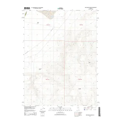
2014 Map of Wild Range Canyon
USGS Topo · Published 2014About this map
Buffalo Valley Hot Springs and the expansive basin of Alkali Lake define this high-desert landscape in Lander County. The map documents the dramatic transition from the flat, arid floor of Buffalo Valley into the rising elevations of the Fish Creek Mountains, where Wild Range Canyon carves into the western slopes. Transportation through this remote terrain is centered on Buffalo Valley Rd and CR-121, providing access to the region's isolated geothermal and hydrologic features. Further east, the terrain becomes increasingly complex, culminating at high points like Pinnacle Mtn. The seasonal drainage of Daisy Cr provides a rare trace of water through the alluvial fans at the base of the mountains, illustrating the survival and movement patterns required in this Great Basin environment.
Find a feature on this map
14 named features on this map. Tap any name to fly to it.
Don’t see what you’re looking for? This feature index may not catch every label — zoom into the map to look around manually.
Map Details
Editions of this 2014 Wild Range Canyon Map
This is the sole edition of this map. No revisions or reprints were ever made.
Other maps of this area

1932 · Sonoma Range
USGS Topo · 1:250,000

1939 · Sonoma Range
USGS Topo · 1:250,000

1955 · Winnemucca
USGS Topo · 1:250,000

1958 · Winnemucca
USGS Topo · 1:250,000

1961 · McCoy
USGS Topo · 1:62,500

1961 · The Cedars
USGS Topo · 1:62,500

1961 · Mt. Moses
USGS Topo · 1:62,500

1962 · Winnemucca
USGS Topo · 1:250,000

1962 · Buffalo Springs
USGS Topo · 1:62,500

1982 · Fish Creek Mts
USGS Topo · 1:100,000