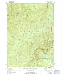
1970 Map of Wild River
USGS Topo · Published 1992About this map
White Mountain National Forest dominates this topographic study of the New Hampshire and Maine borderlands, centered on the drainage of the Wild River. The landscape is defined by the high peaks of Beans Purchase and Shelburne, where the Appalachian Trail crosses through Shelburne Moriah Mtn and Middle Moriah Mtn. Remote mountain infrastructure is well-documented, including the Wild River Climatic Station, several trail-access points like Spider Bridge, and the Blue Brook Shelter. Settlement is sparse in this wilderness, restricted primarily to the northern edge at Gilead and the southern corner near Brickett Place. The intricate water network reveals numerous dramatic features such as the Moriah Gorge, Hermit Falls, and Mad River Falls, illustrating the steep descent of mountain brooks toward the larger river valleys.
Find a feature on this map
68 named features on this map. Tap any name to fly to it.
Don’t see what you’re looking for? This feature index may not catch every label — zoom into the map to look around manually.
Map Details
Editions of this 1970 Wild River Map
3 editions found
Other maps of this area

1893 · Gorham
USGS Topo · 1:62,500

1894 · North Conway
USGS Topo · 1:62,500

1896 · North Conway
USGS Topo · 1:62,500

1896 · Gorham
USGS Topo · 1:62,500

1909 · Fryeburg
USGS Topo · 1:62,500

1911 · Fryeburg
USGS Topo · 1:62,500

1914 · Bethel
USGS Topo · 1:62,500

1937 · Gorham
USGS Topo · 1:48,000

1940 · Bethel
USGS Topo · 1:62,500

1941 · Bethel
USGS Topo · 1:62,500