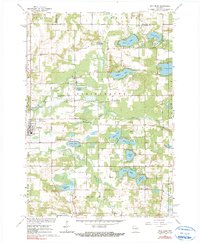
1961 Map of Wild Rose
USGS Topo · Published 1991About this map
Wild Rose serves as the primary hub in this Central Wisconsin landscape, where the town's grid meets the Wild Rose Municipal Airport and the Springwater Nursing Home. The area is defined by a dense concentration of kettle lakes and recreational camps, including Camp Napowan, Camp Windego, and Camp Hiwela nestled near Kusel Lake and Round Lake. Evidence of early settlement and community life is found in the scattered burial grounds such as Dopp Cem, Lane Cem, and Caersalem Cem, alongside rural landmarks like the Little Mission Chapel and Immanuel Ch. The hydrology is complex, with the Pine River and Willow Creek winding through the terrain, supported by artesian features like the Fenrich Springs and a Flowing Well. This survey reflects a mid-century period when the region was firmly established as both a farming community and a destination for youth scouting and lakeside camps.
Find a feature on this map
51 named features on this map. Tap any name to fly to it.
Don’t see what you’re looking for? This feature index may not catch every label — zoom into the map to look around manually.
Map Details
Editions of this 1961 Wild Rose Map
2 editions found
Other maps of this area

1955 · Green Bay
USGS Topo · 1:250,000

1957 · Amherst
USGS Topo · 1:48,000

1957 · Waupaca
USGS Topo · 1:48,000

1959 · Wautoma
USGS Topo · 1:48,000

1961 · Redgranite
USGS Topo · 1:62,500

1961 · Saxeville
USGS Topo · 1:24,000

1961 · Wild Rose
USGS Topo · 1:24,000
1961 · Redgranite
USGS Topo · 1:24,000

1961 · Spring Lake
USGS Topo · 1:24,000
1968 · Wautoma
USGS Topo · 1:24,000