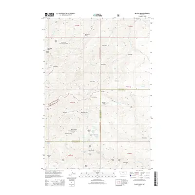
2014 Map of Wildcat Draw
USGS Topo · Published 2014About this map
Gallatin National Forest and Custer National Forest converge in this high-elevation region where the boundary between Sweet Grass and Stillwater counties is defined by drainage divides and ridgelines. The landscape is deeply incised by a network of gulches and draws, such as Sawmill Gulch and Wildcat Draw, which funnel seasonal runoff toward Bridger Cr and Trout Cr. This map reveals a reliance on vital water sources in an arid environment, noting specific points like Wildcat Spring Number One, Tepee Spring, and McKinsey Spring. The terrain transitions from Derby Ridge in the northwest down through complex coulees like Smith Coulee. While development is minimal, the network of service roads like Spring Creek Rd provides access to these public lands, supporting forest management and grazing at the start of the twenty-first century.
Find a feature on this map
49 named features on this map. Tap any name to fly to it.
Don’t see what you’re looking for? This feature index may not catch every label — zoom into the map to look around manually.
Map Details
Editions of this 2014 Wildcat Draw Map
This is the sole edition of this map. No revisions or reprints were ever made.
Other maps of this area

1891 · Big Timber
USGS Topo · 1:125,000

1893 · Big Timber
USGS Topo · 1:125,000

1898 · Granite Mountain District
USGS Topo · 1:125,000

1932 · Nye No 1
USGS Topo · 1:48,000

1932 · Nye No 2
USGS Topo · 1:48,000

1939 · Mt Wood
USGS Topo · 1:62,500

1941 · Mt. Wood
USGS Topo · 1:62,500
1954 · Ross Canyon
USGS Topo · 1:24,000
1954 · Sliderock Mountain
USGS Topo · 1:24,000

1954 · Billings
USGS Topo · 1:250,000