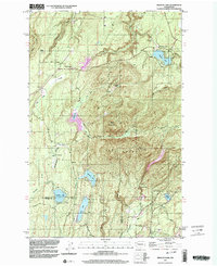
1997 Map of Wildcat Lake
USGS Topo · Published 2003About this map
Gold Mountain and Green Mtn dominate this central Kitsap Peninsula landscape, where a dense network of water bodies and small communities defines the mid-century timber and recreation character. The survey highlights several high-elevation lakes, including Wildcat Lake and William Symington Lake, alongside the prominent Union River Reservoir which serves as a major hydrological feature for the region.
Find a feature on this map
32 named features on this map. Tap any name to fly to it.
Don’t see what you’re looking for? This feature index may not catch every label — zoom into the map to look around manually.
Map Details
Editions of this 1997 Wildcat Lake Map
This is the sole edition of this map. No revisions or reprints were ever made.
Other maps of this area

1936 · Point Misery
USGS Topo · 1:62,500

1937 · Port Orchard
USGS Topo · 1:62,500

1938 · Allyn
USGS Topo · 1:62,500

1940 · Point Misery
USGS Topo · 1:62,500

1942 · Gig Harbor
USGS Topo · 1:62,500

1943 · Gig Harbor
USGS Topo · 1:62,500

1953 · Seabeck
USGS Topo · 1:24,000

1953 · Poulsbo
USGS Topo · 1:24,000

1953 · Burley
USGS Topo · 1:24,000

1953 · Bremerton West
USGS Topo · 1:24,000