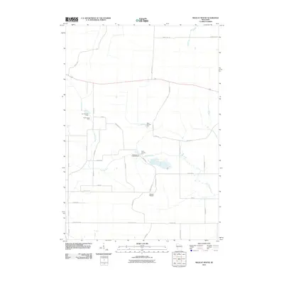
2010 Map of Wildcat Mound
USGS Topo · Published 2010About this map
Wildcat Mound dominates the landscape of this rural section of Clark County, rising above a network of headwaters and small-scale infrastructure. The hydrology of the area is defined by Fivemile Creek, which meanders across the central terrain, supported by a series of water control structures including Dam Number Two and Dam Number Five. These features, alongside the Clark County 1 Dam, suggest a managed drainage and reservoir system within the Wisconsin countryside. The road network is primarily composed of descriptive local lanes like Mound Rd and Bald Peak Ave, reflecting the geographic landmarks of the region. Peripheral waterways such as Pony Creek and Crooked Creek further characterize this drainage basin, which remains largely defined by its natural topography and agricultural-scale engineering as documented in the early twenty-first century.
Find a feature on this map
35 named features on this map. Tap any name to fly to it.
Don’t see what you’re looking for? This feature index may not catch every label — zoom into the map to look around manually.
Map Details
Editions of this 2010 Wildcat Mound Map
This is the sole edition of this map. No revisions or reprints were ever made.
Other maps of this area

1924 · Black River Falls
USGS Topo · 1:62,500

1926 · Black River Falls
USGS Topo · 1:62,500

1948 · Fairchild
USGS Topo · 1:62,500

1949 · Fairchild
USGS Topo · 1:62,500

1953 · Neillsville
USGS Topo · 1:62,500

1953 · Eau Claire
USGS Topo · 1:250,000

1958 · Eau Claire
USGS Topo · 1:250,000

1958 · Hatfield
USGS Topo · 1:48,000

1964 · Eau Claire
USGS Topo · 1:250,000
1968 · Black River Falls
USGS Topo · 1:62,500