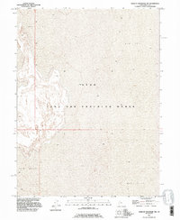
1993 Map of Wildcat Mountain NW
USGS Topo · Published 1996About this map
Utah Test and Training Range occupies the core of this landscape, reflecting the military's long-standing use of the remote Great Salt Lake Desert. The terrain is characterized by a nearly level Mud Flat, a vast dry lake bed that highlights the isolation of the western Utah salt pans. Surveyed during the late 20th century, the map details a stark environment where sparse contour lines emphasize the extreme flatness of the basin floor. This area, north and west of Wildcat Mountain, serves as a critical zone for aerial and ground testing, where the absence of civilian settlements or public infrastructure is a direct result of its designated military role. The minimal topographic variation is interrupted only by subtle shifts in the playa surface, illustrating the unique geological and logistical character of this restricted high-desert corridor.
Find a feature on this map
4 named features on this map. Tap any name to fly to it.
Don’t see what you’re looking for? This feature index may not catch every label — zoom into the map to look around manually.
Map Details
Editions of this 1993 Wildcat Mountain NW Map
This is the sole edition of this map. No revisions or reprints were ever made.
Other maps of this area

1953 · Tooele
USGS Topo · 1:250,000

1954 · Wildcat Mtn
USGS Topo · 1:24,000

1954 · Wildcat Mtn SE
USGS Topo · 1:24,000

1955 · Tooele
USGS Topo · 1:250,000

1973 · Knolls SW
USGS Topo · 1:24,000

1973 · Arinosa SE
USGS Topo · 1:24,000

1973 · Wildcat Mountain SW
USGS Topo · 1:24,000

1973 · Wildcat Mountain NW
USGS Topo · 1:24,000

1973 · Gold Hill 1 SE
USGS Topo · 1:24,000

1973 · Knolls SE
USGS Topo · 1:24,000