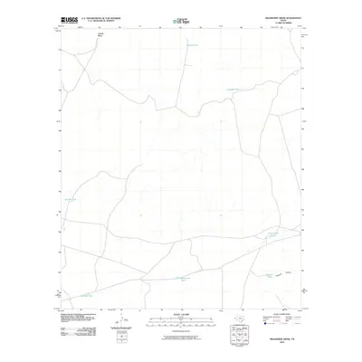
2010 Map of Wildhorse Draw
USGS Topo · Published 2010About this map
Coyote Place anchors the northwestern corner of this West Texas landscape, a region defined by its sparse water resources and vast ranching infrastructure. The network of stock tanks—including Old Rattlesnake Tank, Shakespeare Tanks, and Crowder Tank—illustrates the critical importance of managed water collection in this arid environment. The terrain is marked by gradual elevation changes leading into Peacock Canyon in the southeast, where Peacock Tank sits near the drainage path. This survey provides a clear view of the rural road network and topographic relief in Hudspeth County, showing how localized landmarks like Boulder Tank and Borrego Tank serve as the primary points of reference for navigation and land management across the wide draws.
Find a feature on this map
9 named features on this map. Tap any name to fly to it.
Don’t see what you’re looking for? This feature index may not catch every label — zoom into the map to look around manually.
Map Details
Editions of this 2010 Wildhorse Draw Map
This is the sole edition of this map. No revisions or reprints were ever made.
Other maps of this area

1903 · Cerro Alto
USGS Topo · 1:125,000

1941 · Heuco Mountains
USGS Topo · 1:62,500

1942 · Borrego
USGS Topo · 1:62,500

1943 · Tepee Butte
USGS Topo · 1:62,500

1943 · San Antonio Mtn
USGS Topo · 1:62,500

1943 · Heuco Mountains
USGS Topo · 1:62,500

1954 · Van Horn
USGS Topo · 1:250,000

1958 · Van Horn
USGS Topo · 1:250,000
1977 · Whiterock Hills
USGS Topo · 1:24,000
1978 · Wildhorse Draw
USGS Topo · 1:24,000