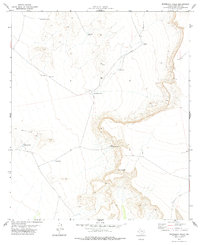
1977 Map of Whiterock Hills
USGS Topo · Published 1978About this map
Whiterock Hills define this high-desert landscape in Hudspeth County, where survival in the late twentieth century remained tied to a sparse network of water improvements. The map illustrates a land organized around stock tanks and wells, including Little Borrego Tank, Red Rock Tank, and Veale Well. This system of catchment and extraction points suggests a ranching economy adapted to the arid West Texas climate, with specific livestock infrastructure like Silva Tank and Level Tank spaced across the terrain.
Find a feature on this map
12 named features on this map. Tap any name to fly to it.
Don’t see what you’re looking for? This feature index may not catch every label — zoom into the map to look around manually.
Map Details
Editions of this 1977 Whiterock Hills Map
This is the sole edition of this map. No revisions or reprints were ever made.
Other maps of this area

1894 · Fort Hancock
USGS Topo · 1:125,000

1903 · Cerro Alto
USGS Topo · 1:125,000

1942 · Borrego
USGS Topo · 1:62,500

1943 · Tepee Butte
USGS Topo · 1:62,500

1943 · Finlay Mountains
USGS Topo · 1:62,500

1943 · Fort Hancock
USGS Topo · 1:62,500

1954 · Van Horn
USGS Topo · 1:250,000

1958 · Van Horn
USGS Topo · 1:250,000
1972 · Fort Hancock NW
USGS Topo · 1:24,000
1972 · Cavett Lake
USGS Topo · 1:24,000